About
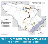
The Route 1 Corridor Master Plan was initiated to develop recommendations on revitalization strategies specific for Route 1 and was anticipated to be an amendment to the current General Plan, PlanHoward 2030. In July 2020, the County accelerated the next General Plan update and launched HoCo by Design, a process that will update PlanHoward 2030.
With both projects occurring simultaneously, the Route 1 Corridor Master Plan process will be folded into the General Plan update. Through the Route 1 Corridor Master Plan process, RKG & Associates prepared reports and recommendations based on community input received and physical assessments conducted along the corridor. The results of that effort have been summarized in a series of subject matter assessments which will serve as baseline data to inform a more comprehensive evaluation of Route 1 as part of HoCo By Design. Included in these assessments are an Executive Summary, a Market and Trends Assessment, a Transportation and Transit Assessment and Land Use and Urban Design Assessment.
Integrating the Route 1 planning effort into the General Plan Update allows for a more comprehensive evaluation of the Route 1 corridor and an opportunity to evaluate Route 1 in a wider context relative to Howard County as a whole. HoCo by Design will model different growth scenarios along the various corridors in the County and evaluate the impacts on transportation, infrastructure, fiscal, and other measures. The Route 1 Corridor Master Plan did not have a modeling component to the project so additional analysis will be completed as a result of this consolidation. Integrating these efforts will also provide a more holistic review of the corridor, as the HoCo by Design team is comprised of local and national consultants with experience and expertise in areas of market and economics, environment, transportation, urban design and redevelopment.
WANT TO STAY INFORMED?
Please check this page regularly for updates on meetings and events. If you would like to receive regular email updates, please sign-up here
Corridor Overview
Title
Background
Content
Transportation
For many years Route 1 was the preeminent north-south connector for long distance travel along the east coast, however, I-95 has now taken over that function. As a state highway, Route 1 handles more local and regional trips. Parts of the corridor have undergone piecemeal infrastructure upgrades, road widenings and a pending projects to implement advanced signal technology, but its design does not readily accommodate multiple transportation modes. There are few sidewalks, very few opportunities to safely cross, pedestrian lighting is poor or non-existent, and there are no separate bicycle facilities. While Route 1 functions in some ways as an arterial, because of its character, the broad range of abutting land uses, and intersecting streets and driveways, motorists experience periodic delays, and pedestrians and bicyclists are exposed to unsafe conditions. There were 23 pedestrian collisions resulting in 18 injuries and 6 fatalities in the corridor in 2016. Residential neighborhoods, employment areas, commercial centers, and recently completed mixed use developments are dispersed along the Route 1 corridor. However, many are beyond an easy walk of Route 1 and most are disconnected from one another. There is bus service, but it is limited in coverage and frequency (mostly 1-hour headways). The corridor’s eastern perimeter is served by commercial and residential rail service. The MARC Camden line provides opportunities for commuter travel to and from the rest of the Baltimore-Washington region and has attracted some transit-oriented development. Recently, the Maryland Department of Transportation supported expanding commuter rail service with an added stop at Laurel Park Station, in Howard County. However, service is limited to peak weekday hours due to constraints imposed by the track owners, CSX. While existing MARC stations in the County are readily accessible by car, access is limited for cyclists, pedestrians, and bus riders.
Employment
Howard County boasts low unemployment, access to top-notch academic institutions, and a highly-educated workforce. The County is also well-positioned for success in the area of cybersecurity. It is close to Fort Meade, Washington, D.C., Baltimore, and many of the nation’s most important federal institutions, and is home to the Johns Hopkins University Applied Physics Lab, which employs about 5,600 people and is planning for added growth. While the Route 1 corridor is only 8% of the County’s land area, it accommodates 30% of its jobs. In the greater Baltimore metropolitan area, cybersecurity is one of the fastest growing and increasingly important industries. The Baltimore-Washington corridor is one of the most concentrated in the US in terms of cybersecurity talent and is comparable with regions such as San Francisco, Seattle, and Boston. As Fort Meade, the nation’s epicenter of cybersecurity and information systems, continues to grow, the County could capitalize on its expansion. Fort Meade generates approximately 55,000 jobs on-site, another 110,000 jobs off the base. Over 13,000 County residents currently work at the Fort Meade campus. Over the coming years, extensive growth is projected to continue at Fort Meade in support of the National Security Agency, Defense Cyber Command, and Service Cyber Headquarters. The combination of these factors have added over the last decade, and continue to add, upwards of 10,000 more positions to the Fort Meade workforce. Many cybersecurity jobs in the County are currently located within the Route 1 corridor, or nearby. While an important employment corridor for the County, Route 1 is lined with many blighted commercial and industrial buildings and properties that have been lacking reinvestment for decades. Plan recommendations should identify revitalization tools, including feasible financial incentive programs to consolidate parcels and rehabilitate properties. These recommendations could augment or supplant the current tax credit program.
Land Use
The corridor makes up about 8% of the County land area, 13,500 acres of a total 160,640 acres in the County. About 22% of the Route 1 land area is developed residential and 6% undeveloped residential. However, the CAC and TOD mixed-use zones placed over current commercial and industrial land after the 2000 General Plan may allow for further residential development as part of mixed-use communities. Retail and office/service uses account for 8% of the Route 1 corridor. Only 1% of the land is undeveloped retail or office/service use. A full 23% of the acreage in the corridor is utilized as industrial. Only 2% is undeveloped industrial. Government and institutional uses account for about 9% of the land area, and parks and open space account for 16%. The remaining 12% of the land area is dedicated to roads and utilities. About 49,000 residents live in approximately 19,000 housing units in the Route 1 corridor. This is about 15% of the total 320,000 residents living in Howard County. About 38% of these 19,000 homes are single family detached units, 33% are townhomes, and 26% are rental and condo apartments. The remaining 3% are 635 mobile homes in eight mobile home parks. Several mobile home parks have closed and been converted to apartment and townhouse communities over the last decade and more closures are on the horizon.
2017-2020 Master Plan Effort
Title
About the Plan
Content
Howard County’s new Rt. 1 Corridor Master Plan will activate transportation, infrastructure, land use and economic development implementation strategies to improve vibrancy and livability throughout the Route 1 corridor. The broader target area extends from I-95 to the southeastern county line; while the specific plan area - designated for detailed planning and implementation purposes - includes properties abutting Route 1 and stretches east to the county line.
The Department of Planning and Zoning will be assisted by a nationally known economic, planning, and real estate consultancy, RKG Associates, and their project team. The process will result in conceptual development/design scenarios and identify implementation tools that are grounded in market realities. Land use and transportation analysis will form the basis of the strategy along with input gathered through a series of public engagement initiatives. The effort will build on and will be informed by the many previous Route 1 specific studies (see below) such as the recent US 1 Safety Evaluation and broader initiatives such as the Development Regulations Assessment, an initial examination of the county’s zoning code.
Among the key questions to be answered as part of this study are:
- What should be the overarching vision for the corridor - or are there multiple visions, guided by a specific geography and existing development character?
- Is mixed use development a viable concept? If so, what form should it take and where should it be focused?
- How should Route 1 function as a roadway to support the corridor's vision and to maintain the viability of local businesses and the safety of pedestrians and motorists?
- How can the character and quality of development and the environment be enhanced?
- What are successful examples from around the country that can be used as potential templates for development on Route 1?
The implementation strategy starts in Fall 2018 with stakeholder interviews, a business roundtable, and public open house/workshop events. A corridor analysis and conceptual design scenarios and the preliminary results of this outreach, are anticipated to be presented to the public in the Spring of 2019. the final implementation strategy is scheduled for completion in Fall 2019. The Rt. 1 Corridor Master Plan will be a plan amendment to the County's General Plan, PlanHoward 2030, and will go before the Planning Board and the County Council for review and adoption.
Why Develop a Route 1 Corridor Plan?
Image
The nearly 12-mile stretch of US Route 1 is an essential part of the vibrant neighborhoods and economy that helps define Howard County. The corridor makes up about 8% of the County land area, (13,500 acres of a total 160,640 acres in the County), it accounts for larger percentages of the county's total residents and jobs.
Image
![]()
About 49,000 residents live in approximately 19,000 housing units in the Route 1 corridor, representing approximately 15% of Howard County's 320,000 residents. In addition, Route 1 is an important economic and employment engine for the county, as 30% of jobs in the county are located along the corridor.
Overall, the Route 1 corridor comprises a diverse range of land uses that includes the following:
- About 22% of the Route 1 land area is developed residential and 6% undeveloped residential. Retail and office/service uses account for 8% of the Route 1 corridor. Only 1% of the land is undeveloped retail or office/service use.
- A full 23% of the acreage in the corridor is utilized as industrial. Only 2% is undeveloped industrial.
- Government and institutional uses account for about 9% of the land area, and parks and open space account for 16%.
- The remaining 12% of the land area is dedicated to roads and utilities.
Title
Community Engagement
Content
Route 1 Roundtable Discussion and Breakfast
Larry Twele, CEO of the Howard County Economic Development Authority (HCEDA) hosted a Route 1 Roundtable Discussion and Breakfast at the Savage Firehouse in Savage, MD. Russ Archambault, VP and Principal of RKG Associates was the primary speaker. He offered their initial observations about the corridor and facilitated a brief discussion with attendees about where business leaders believe the corridor should be heading in the future. Twenty five business representatives and corridor leaders were in attendance. Attendees offered a wide variety of considerations related to transportation, zoning, economic conditions and asked about the project approach.
Project Open Houses
Open Houses were held in the Fall 2018 to solicit community input on existing land use, transportation and economic conditions and gauge personal preferences for each. The information will be analyzed, along with other base data, to inform the vision(s) for the corridor and test redevelopment scenarios in later planning phases.
Open House stations included information boards, write-in comment questions, mapping exercises and preference surveys, which consisted of the following topics:
- Prior Planning Initiatives
- Land Use Character
- Getting Around
Virtual Open House: Comment Period Closed
The Virtual Open House is accessible for viewing its community mapping exercises but is no longer open for public comment.
This web tool is designed for use on a computer or laptop browser.
We recommend you open the Virtual Open House User Guide so it’s available to you as you navigate the virtual open house.
Virtual Open House
This Virtual Open House seeks additional input for the plan by reproducing each station’s content with interactive input activities in digital formats. We hope this provides a useful platform for sharing what you know about the corridor, and your ideas on how to improve its vibrancy and livability.
Please contact us with any questions at planning@howardcountymd.gov or 410-313-2350.
Image

A huge thanks to all who participated in the plan’s Phase 1 Open Houses. Your input resulted in more than 1,300 comments by over 200 people! The information has been compiled and captured in our Phase 1 Open House Results module which includes all the mapping data, comment board and survey responses collected during the process. The information has been shared with the plan's consultants to make informed decisions through the next phases of the project.
Phase II Workshop
View June Workshop Presentation
View the Stations for a Breakdown of the Plan:
Stations cover the project's overview, what we've learned from you, existing conditions, character areas, connectivity and implementation.
Phase II Workshop Results Are In!
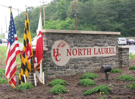
A huge thank you to all who participated in the summer Phase II workshops. Public workshops were held during a hot spell in June in Elkridge and North Laurel to review and provide feedback on the Plan's economic, land use, and transportation strategies being considered for the Corridor. Attendees first heard a presentation by the project team before walking through a series of stations with survey questions on the concepts and preliminary considerations presented.
A Phase II Virtual Workshop was open over the summer, which replicated the in-person workshop's presentation, stations, and survey. Results can be viewed here, the presentation and station materials are below.
Title
Project Team
Content
RKG Associates: RKG Associates is an economic, planning, and real estate consultancy with offices in Washington, DC, Boston, Atlanta, Dallas, and Durham, NH. Founded in 1981, RKG is accomplished at assessing the economic, fiscal, and operational aspects of development projects. RKG has worked with public and private entities and economic development agencies across the country in developing implementable strategies for redevelopment, reuse, and revitalization.
RKG Project Lead
Russell Archambault, VP and Principal
Mr. Archambault has over 32 years of experience in community and economic development. Mr. Archambault has applied his experience to managing urban and waterfront redevelopment, development feasibility, local and regional economic analysis, military base reuse planning, and transportation economics. Mr. Archambault leads RKG’s fiscal planning which assists local governments in understanding impacts of local land use decisions and policies.
Rhodeside & Harwell: Rhodeside & Harwell, Inc. (RHI) strives to make places that connect people to each other and their environment. With an acclaimed portfolio focused on building timeless spaces and livable communities, and a staff of 29 professionals, RHI has directed many of the country’s most compelling public realm projects. RHI is committed to making the ever-expanding urban realm more livable, beautiful, and functional. Addressing the contemporary challenges of aging infrastructure, shrinking green space, and growing populations requires novel approaches.
Rhodeside and Harwell Project Lead
Deana Rhodeside, PH.D, Director- Planner – Community Engagement Specialist
For the past three decades, Deana Rhodeside has been engaged in the creation of plans that strengthen our cities and their communities, and encourage places of personal satisfaction and collective well-being. She has directed many broad-based initiatives focused on creating “sense of place” in ways that reflect the culture, history, socio-economic challenges and desires within each community. She is adept at designing an engagement strategy for each project – whether a corridor, a neighborhood, a downtown, or a public space — that uniquely responds to the issues inherent in that particular task.
W-ZHA: Whether it be strategic plans, a new regulation, an infrastructure investment, or a public/private development project, to be successful visions must be rooted in market, economic and finance realities. W-ZHA provides the analytics necessary for informed public policy decision making.
Toole Design Group: Toole Design Group is the nation's leading planning, engineering and landscape architecture firm specializing in bicycle and pedestrian transportation. Our focus is developing creative yet practical solutions that move people more efficiently, while improving the quality of life of the community.
FourSquare ITP: FourSquare ITP is a multi-modal transportation planning firm focused on providing innovative transportation solutions that are practical, focused, and implementable.
Resources
Title
Prior Route 1 Studies
Content
Route 1 Manual
The purpose of the Route 1 Manual is to present requirements and recommendations to: improve the visual appearance of the corridor's streetscape, enhance the appearance and value of developments in the corridor, and establish the desired design character for new developments in the Corridor Employment (CE), Transit Oriented Development (TOD), and Corridor Activity Center (CAC) Districts.
![]()
Additional Route 1 Resources